- Homepage
- Brand
- Adidas (523)
- Barnegat Bay Decoy (15)
- Caikag (36)
- Ccm (124)
- Fanatics (79)
- Fanatics Authentic (25)
- Fanatics Branded (38)
- Forever Collectibles (14)
- Green Bay Packers (14)
- Hampton Bay (25)
- Logo Athletic (13)
- Majestic (121)
- Mdf (21)
- Mitchell & Ness (335)
- Mitchell And Ness (16)
- Nike (1626)
- Reebok (426)
- Russell Athletic (35)
- Starter (26)
- Wilson (31)
- ... (1624)
- Capacity
- League
- Player
- Aaron Rodgers (370)
- Bart Starr (45)
- Brett Favre (187)
- Clay Matthews (32)
- Devin White (45)
- John Lynch (34)
- Jordan Love (30)
- Klay Thompson (84)
- Martin St. Louis (42)
- Mike Alstott (42)
- Mike Evans (53)
- Nikita Kucherov (83)
- Ray Nitschke (34)
- Reggie White (65)
- Rob Gronkowski (58)
- Stephen Curry (48)
- Steven Stamkos (131)
- Tom Brady (544)
- Victor Hedman (34)
- Vincent Lecavalier (74)
- ... (3132)
- Product
- Authentic Jersey (5)
- Ball (2)
- Baseball Jersey (2)
- Bobblehead (18)
- Display Case (18)
- Football Jersey (7)
- Helmet (4)
- Hoodie (3)
- Jersey (3068)
- Jersey Shirt (2)
- Jerseys (427)
- Lot (3)
- Nfl Football Jersey (7)
- Nfl Jersey (3)
- Puck (2)
- Shirt (5)
- Sign (6)
- Single (19)
- Sweatshirt (2)
- Vintage Nos Jersey (15)
- ... (1549)
- Sport
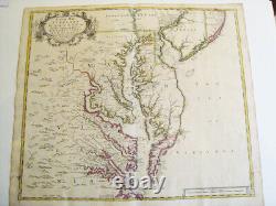
Chesapeake Bay, Virginia, Maryland, New Jersey. Original Map. John Senex London


Double page engraved map with outline original colouring, 53 x 30 cm. Third state of Christopher Browne's seminal map, first issued in 1685 but here with changes to the cartouche and dated 1719. It was published in John Senex's A New General Atlas, London, 1721, and is a revised state of Christopher Browne's map, an important delineation of the Chesapeake Bay region, derived mainly from the earlier surveys of Augustine Herrman (1673).
This is also one of the earliest maps to adopt a North-South orientation on the page. The boundary for Delaware (then part of Pennsylvania) is represented favoring the claims of Lord Baltimore, rather than the Cape Henelopen boundary, which was finally ratified by the British Courts when the dispute was settled in the 1730s and finally mapped by Mason & Dixon several decades later. New Jersey is divided into East and West Jersey. From Senex's New General Atlas, London, 1721. The boundary for Delaware (then part of Pennsylvania) is represented favoring the claims of Lord Baltimore, rather than the Cape Henelopen boundary, which was finally ratified by the British Courts when the dispute was settled in the 1730s and finally mapped by Mason & Dixon.

